Dogs Off-leash

E-Bikes
Not Allowed
Features
Drops/Jumps
Overview
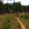
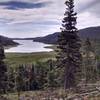
This shuttle trail takes you down 4,400 feet of gravity fueled fun. It has rock gardens, and a well built flow trail ending in a beautiful canyon where you'll be surrounded by beautiful conglomerate rock features. You'll need a shuttle to do this or some incredibly strong legs. Expect high speed corners, and be careful where you stop as others will be flying down this trail. The trail rides through ancient cottonwood's and pines, many of which have been burned to the ground by a tragic fire.
Need to Know
You can arrange a shuttle at Brian Head Resort. It's a short shuttle up to Brian Head Peak and they pick you up at the pavement at the bottom. You can also self-shuttle.
Description
This trail starts near the top of Brianhead peak, Park near the Pit Toilets. Start right out of the parking lot by crossing the road and riding up a short steep hill. Don't be surprised if you start to wheeze as you can feel the elevation as you are near 11000 feet high. As you summit the hill follow the Sydney peaks trail for 1 mile before taking a left onto the well marked trail of Dark Hollow.
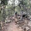
Once on Dark Hollow you'll be faced by the hardest section of the trail. a short rock garden lasting one switchback. Work your way through rocks and rollers, before reaching a flat singletrack trail for another mile. From here pedal the flat trail until reaching a doubletrack road. Once on the doubletrack follow it down trail and cut back right onto Dark Hollow Trail.
From here ride well built berms and a fast flow trail to the bottom. Expect loose corner's and few obstacles on the trail. a few small drops exist and drops. Keep your eye out for a skinny or two to ride as well. Once reaching the dirt road (second left hand road) follow it down the canyon for 6 miles of gravity fueled fun. Surprisingly the road rides better than imagined. Once at the end of Second left hand road take a right where you should have left a Vehicle parked at The Forebay here at the bottom.
Contacts
Shared By:
Kevin Christopherson
with improvements
by Marley Nelson

 Continue with onX Maps
 Continue with Facebook


 Intermediate/Difficult

 4.4 (19)


")


4 Comments