(Latest GPS track and description include reroutes made by the Forest Service.)
This trail is most commonly ridden in 2 different ways;
1. as a 11.3 mile singletrack extension of the
Monarch Crest Trail after
Silver Creek Trail, heading east, to Hwy 285/Mears Junction, before rolling down into Poncha Springs. Although the elevation profile makes this section of the Rainbow trail look relatively mild, tired legs make for a hard ride after Monarch Crest/Silver Creek.
2. as part of a 20.5 mile loop, the Hwy 285/Mears Junction - County Rd 47YY/Silver Creek Rd - Rainbow Trail loop. Park at the end of this section of the Rainbow trail at Hwy 285/Mears Junction, ride up County Rd 47YY/Silver Creek Rd, which is a fairly easy gradual climb and only gets hard near the end, right before the Rainbow trailhead. Then ride the Rainbow trail back to Hwy 285/Mears Junction with fresher legs; this is a favorite loop for the locals, early in the season, before the Monarch Crest opens up in early July (typically).
Look for the Rainbow Trail sign just off the County Rd 47YY/Toll Road Gulch, on the South side.
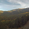
Heading east the trail begins as a mellow ride before it gets to several creek crossings, with increasingly steeper and narrow switchback climbs out of those creeks. As this is an older moto trail some of the uphill grades aren't very mountain bike friendly and these short climbs require good bursts of energy to clean. No shame in walking any of them.
Basically the trail turns into the hill, then climbs back out onto the sides where great views provide a mental break, before slowly dipping down on some fast & beautiful sections of skinny singletrack. Rinse & Repeat.
After 7 or so miles the character changes and the trail becomes rougher & rockier, both on the uphills and especially on the extended downhills. If you're tired, this is where you'd crash. Where in the past the trail finished by going almost straight down the last hill to Hwy 285 (with a few awkward switch-backs), the Forest Service has rerouted this last section by adding almost a mile long contour trail, with longer turns and better flow. This new section is narrow and a blast to ride. It continues until the trail dumps you out on Hwy 285 @ Mears Junction.
Either roll down the hill to Poncha Springs or Salida, or open up that cold beer stored in the cooler in your car if you did the loop. Or, cross the road and continue on the Rainbow Trail, if you're crazy enough....

 Continue with onX Maps
 Continue with Facebook


 Difficult


4 Comments