Dogs Unknown

E-Bikes
Unknown
Description
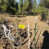
At the end of Babbitt Drive (near Sam's Club) the Arizona Trail starts rather inauspiciously as a paved access road leading past one of Flagstaff's sewage treatment facilities and then under Interstate 40. Just as you go under the eastbound lanes of the highway, the trail turns to gravel and circles a small pond before taking off uphill into the pines. From here the riding is on old jeep roads and singletrack. All intersections are well signed toward
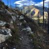
Fisher Point. Early on the trail passes very close to the ignition point of the 2010 Hardy Fire. Damage near the trail is minimal, although there are a few scorched trees and evidence of fire breaks that were constructed for containment.
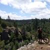
The trail gradually descends to the head of Walnut Canyon, with
Fisher Point rising above. Signs mark the way toward the
Fisher Point lookout, but a short detour to the entrance of Walnut Canyon is worthwhile to check out the shallow cave and looming rock. There is a trail that continues into Walnut Canyon toward the National Monument that would make an interesting side-excursion on foot.
The hard work on this ride (and only section of "Intermediate" riding) involves getting from the canyon floor to the top of
Fisher Point - a climb of ~400 feet in just over a mile. The ascent has a few short steep stretches and some challenging obstacles. You'll know you're at the end when you reach a sign for the short spur trail to
Fisher Point.
Contacts
Shared By:
Almonzo Wilder

 Continue with onX Maps
 Continue with Facebook


 Intermediate/Difficult


 All Clear


0 Comments