Dogs Unknown

E-Bikes
Unknown

Closed May 6-July 1, 2019 for elk calving. As of July 1, 2018 all trails in this area are open.
Overview
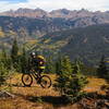
One of the very best link-ups around Vail: almost all singletrack over a long and varied day that combines high-altitude alpine scenery, great cross-country singletrack, and Vail resort's impeccably maintained flow trails.
Need to Know
Either set up a shuttle or use one of the many commercial services to get to Vail Pass. The trailhead is a few miles from the parking lot at the pass, so either drive yourself the the actual trailhead, or cruise the easy dirt roads on your bike (adding a couple miles to your day).
Description
Head up
Bowmans Shortcut, which is very steep in places, for about 700 vertical feet to the aptly-named
"Top of the World". Soak in the 360 degree views from the alpine meadow, then continue downhill to Two Elk Pass. This section is very rutted and technical in places.
Once at Two Elk Pass, ignore the
Two Elk Trail (it will look very tempting, and it is fabulous, so come back for it some day!). Head up the unsigned trail that goes up Mongolia Bowl (this is the Two Elk
Connector). Though it goes up a couple hundred vertical, it's surprisingly easy and non-technical.
Pass straight through the Poma lift and you'll find yourself on a ridge on top of Vail ski area. Great views on either side. Keep your eye out on the left side of the ridge and you'll find an obvious notch that you must downclimb about 30 feet. This is the only way off the ridge.
You are now at the top of the Orient Express lift. Follow the major dirt road along the top of the ridge, passing the Two Elk lodge and a few more lifts until you get to Patrol Headquarters. This is easy to identify as the intersection of 3 major lifts and you'll find signs for the
Grand Traverse Trail.
Follow
Grand Traverse downhill through fantastic singletrack across bowls and through forests. Really fun! After a couple miles, you'll be at the top of the Lionshead gondola.
There are many options here, including getting a beer and the riding the gondola down (for free)...
But you're at the top of some great trails, so pick one. The one that best fits this ride is
Radio Flyer, a really fast and fun flow trail. From the bottom of
Radio Flyer, the best intermediate sequence down is
Lower Radio Flyer to
Big Mamba to
Hank's Hideaway, or if you're getting tired, just stick on the dirt road.
After roughly 20 miles and almost 5,000 feet of descending, you end up at the base of Lionshead Village in Vail, hopefully with a huge smile!
History & Background
You are riding through and above Vail's back bowls, which are almost devoid of trees due to weather conditions in the hot, dry year of 1879 when forest fires ravaged many mountain slopes in Colorado. The fires left the wide-open slopes and sweeping vistas of Colorado high country that made the Back Bowls famous among skiers.
Contacts
Shared By:
Nick Wilder
with improvements
by Jeff Brown

 Continue with onX Maps
 Continue with Facebook


 Difficult

 4.6 (39)


3 Comments