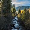
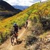
This long ride provides plenty of climbing and plenty of descending through open meadows, dark timber forests, aspen groves, and red rock shrub oak. Much of the climbing takes place on dirt roads, but nearly all of the descending takes place on high quality singletrack. Much of the riding is intermediate level, although the the epic conclusion - the Sunnyside trail - should be considered difficult (at least) given sections where the narrow trail traverses extremely steep terrain, and rocky and rooted sections demand your fullest attention.
This is a big ride that allows for true backcountry experiences. If unfamiliar with the area, be sure to bring a map or the MTB Project mobile app. Cell phone service disappears at the farthest reaches. There are many options along this route to add mileage, or to cut the ride short and coast back down to Aspen.
Start at the base of Smuggler Mt. Road. Climb up the road to the Smuggler Observation Deck where you'll find an information kiosk and map. At this point you could increase the ride length by continuing on BTS, Tootsie Roll, Lollipop, and Iowa Shaft trails. Main route continues to the left on the
Hunter Creek Cutoff trail, which will take you all the way to the
Hunter Creek Trail on the HC valley floor. (Note that this Cutoff trail requires a left hand turn towards the end, to avoid continuing on the
Hunter Valley North trail.)
Make a right on the HC trail, and follow it for several hundred yards before making left to cross over the 10th Mountain Bridge. After crossing the Hunter Creek via the bridge, this route takes the trail to the left, which connects to the Parking area at the WRNF boundry. (This parking area is signed for handicap and senior parking only, and is not typically used by mountain bikers.) You could optionally take the trail to the right, and then take a left on the
Hunter Valley North trail, this will get you back on the same route.
From the Parking area, start climbing
Red Mountain Rd., this 4wd dirt road climbs up to the 4 Corners and Van Horn Park areas, and beyond. It's steep on occasion, and shade is very limited during middle of the day, so make sure to have plenty of water. During this climb, you'll pass by trailheads for Upper
Plunge (on the left), and Lower
Plunge (on the right). These are signed by the WRNF as "Sunnyside" trail, but that is somewhat confusing as you won't really get to Sunnyside trail proper until much later.
Still climbing, you'll encounter a fork in the jeep road. Left continues up to 4 Corners. This route goes right towards Van Horn Park. After the fork you'll pass through a flat meadow for a couple hundred yards. At the end of the meadow, the road continues steeply up to Van Horn Park. This route leaves the road, and makes a right to follow the
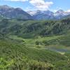
Hunter Creek (Overlook) trail. A short climb will break you out to a steep hill side that offers sweeping views of the Hunter Creek valley below. Watch out for a technical rock feature at this point. The singletrack continues traversing and climbing this hillside, eventually opening to a meadow on the backside of Van Horn Park. When the singletrack ends, make a left on the old jeep road to continue this route. (The road to the right continues for quite a distance to the Wilderness boundary - save that exploration for another day.)
A gentle climb on the jeep road will bring you to a four way intersection that's considered the center of Van Horn Park. From here, this route will make a right to find the Hobbit trail. You could continue straight and descend back down to
Red Mt. Rd. if you need a quick exit for thunderstorms. You could also make a left and climb up a quarter mile to experience big views from VHP's high point.
You'll find the signed Hobbit trail within a hundred yards of the four way intersection. A gruelingly steep climb through aspen trees will get you to a high point where the real fun begins! From here it's a super sweet descent to 4 Corners, with a few short ups along the way.
At 4 Corners, find the direction that will take you towards Red Mt. and the FAA antennae structure. A hundred yards later, make a left onto the signed
Secret Trail.
Secret trail briefly coincides with Upper
Plunge. Make a right, then a left to continue on Secret trail. This segment is also called Jedi trail. Rolling terrain and excellent descending takes you to the Sunnyside trail.
Make a left onto Sunnyside trail. A bit more climbing will take you onto a big traverse of the face of Red Mountain. This is one of the best trails in the area, but keep in mind it's expert level rating.
A very long descent, fast and smooth at times, slow and technical at others, with one paved road crossing (Careful!) will deposit you down to the paved Rio Grande trail. Make a left to get back to Aspen.

 Continue with onX Maps
 Continue with Facebook


 Difficult

 4.3 (44)


7 Comments